Best offers
in Turkiye
Land Plots in Mersin

Affordable Coastal Depth
Mersin land is naturally relevant for residential expansion, port-linked commercial positioning, and scalable development formats because the city combines long coastline availability with inland growth capacity and a comparatively flexible urban cost structure
Linear City Form
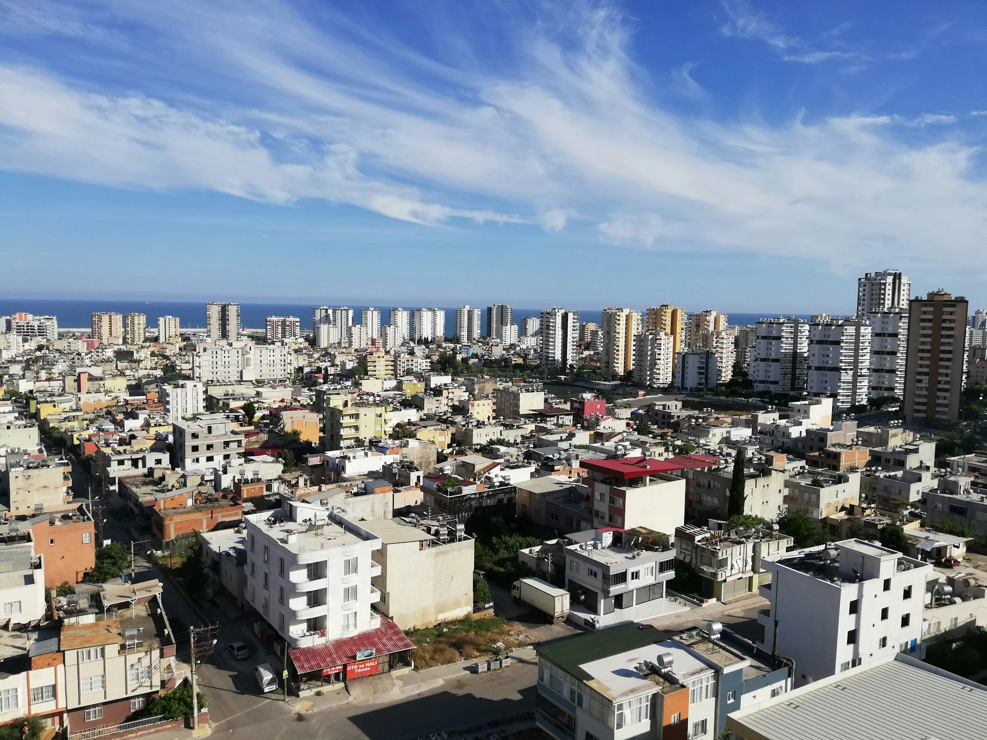
Land in Mersin is shaped by a long coastal strip, parallel urban corridors, and inland residential spread, making plot appeal dependent on connectivity, depth from the shoreline, and how each site aligns with the city's linear metropolitan pattern
Logistics Growth Logic
The strategic appeal of land in Mersin comes from port activity, infrastructure expansion, and steady population growth, allowing well-positioned plots to serve residential or commercial use cases within a city that continues to extend along its transport spine
Affordable Coastal Depth
Mersin land is naturally relevant for residential expansion, port-linked commercial positioning, and scalable development formats because the city combines long coastline availability with inland growth capacity and a comparatively flexible urban cost structure
Linear City Form
Land in Mersin is shaped by a long coastal strip, parallel urban corridors, and inland residential spread, making plot appeal dependent on connectivity, depth from the shoreline, and how each site aligns with the city's linear metropolitan pattern
Logistics Growth Logic
The strategic appeal of land in Mersin comes from port activity, infrastructure expansion, and steady population growth, allowing well-positioned plots to serve residential or commercial use cases within a city that continues to extend along its transport spine
Useful articles
and recommendations from experts
Buying land in Mersin through coastal corridor market logic
Why land plays a practical role in Mersin
Mersin is a coastal city where land decisions are closely tied to its linear urban structure and economic function as a logistics and residential center. Unlike resort-focused markets, land here often supports everyday urban use rather than purely seasonal lifestyle concepts. Buyers consider plots in Mersin because the city still offers spatial availability combined with infrastructure depth, allowing land to function as a rational entry point into long-term residential or development planning.
The relevance of land in Mersin comes from its balance between affordability, scale, and connectivity. A plot can serve as a foundation for residential building, mixed-use projects, or commercial formats aligned with the city’s port-linked economy. This makes land not only a lifestyle decision but also a structured urban positioning choice.
How land fits Mersin's spatial and urban pattern
Mersin’s form is defined by a long coastal corridor with urban expansion moving both along the shoreline and inland. This creates a layered but elongated metropolitan structure where land value depends on how well a plot connects to transport routes, residential districts, and service infrastructure rather than on a simple center-versus-suburb distinction.
Plots near the coastal strip often emphasize visibility and residential demand linked to seaside living, while inland sites can provide more flexible scale and practical development conditions. The city’s linear growth means that access and integration into the urban spine are usually more important than nominal proximity to landmark areas.
This spatial logic makes plot selection in Mersin more about connectivity and surrounding urban density than about prestige labeling. A site that sits inside a coherent growth corridor can be more functional than one closer to the shoreline but less integrated into the broader city pattern.
Main land-use clusters shaping decisions in Mersin
The dominant cluster in Mersin is residential and development-led urban use. Buyers frequently seek plots suitable for apartment complexes, low-rise housing schemes, or villa-style developments aligned with the city’s expanding population base. This reflects Mersin’s role as a working metropolitan area rather than a purely tourism-driven destination.
The secondary cluster involves logistics-related commercial or mixed-use positioning. Certain plots gain relevance because they align with transport infrastructure, port activity, or service corridors supporting trade and industry. While tourism plays a minor role compared to other coastal cities, the city’s economic diversity supports flexible land utilization.
Agricultural-edge or speculative holding logic may exist on the outskirts, but it is not central to city-level land decision-making. Mersin’s primary identity remains tied to practical urban growth and infrastructure-driven demand.
Which land categories typically make sense in Mersin
Buyers exploring land plots in Mersin often compare three categories. The first is coastal residential land, where the aim is to align with seaside housing demand. The second is inland expansion land, offering greater scale and adaptability for residential or mixed-use projects. The third is corridor-linked land, where access to major transport routes supports commercial or service-oriented use.
These categories address different strategic objectives. Coastal plots may emphasize lifestyle appeal and market visibility. Inland plots often support phased development or larger residential schemes. Corridor-linked plots can provide logistical or commercial flexibility when urban integration conditions are favorable.
What makes one plot more practical than another in Mersin
Practicality in Mersin starts with connectivity. A well-positioned plot within the city’s transport network is generally more usable than one isolated from main corridors. Parcel shape and scale also matter because they determine whether the site can support efficient residential or commercial layouts.
Buyers should assess how a plot aligns with population growth patterns and infrastructure distribution. In a city with linear expansion, similarly priced plots can perform differently if one has stronger integration into residential density and service access.
Evaluating land through real urban conditions rather than descriptive labels helps clarify which sites offer stable long-term usability. A parcel that fits naturally into the metropolitan pattern typically provides more predictable outcomes.
Land versus fixed property formats in Mersin
Ready-built apartments or houses provide immediate functionality. Land offers strategic flexibility. In Mersin, this distinction is significant because the city still contains areas where development potential can outperform existing built options. Buyers may choose land to control project scale, building typology, or long-term staging in ways that fixed property cannot accommodate.
However, land becomes attractive only when it enables a clearer or more efficient solution than the ready-built market. If the intended use aligns closely with existing housing stock, completed property may remain the simpler path.
How to interpret real land plots in the VelesClub Int. catalog
When reviewing buildable land in Mersin, buyers should first define the intended use case. Whether the goal is residential construction, a mixed-use project, or a commercial concept, clarity at this stage narrows the range of relevant plots. The next step is to evaluate how each parcel fits the city’s linear spatial logic.
Comparing access, surrounding density, infrastructure proximity, and parcel geometry allows for disciplined decision-making. The VelesClub Int. catalog supports this process by organizing land options according to practical urban criteria rather than promotional emphasis.
Structured guidance helps buyers move from general interest in Mersin toward targeted plot selection. This approach ensures that land decisions align with the city’s real growth dynamics and infrastructure framework.
Questions buyers often ask about land in Mersin
Why does land in Mersin behave differently from resort cities? Because the market is driven by residential expansion and logistics infrastructure rather than seasonal tourism cycles.
Where does land usually make the most sense in Mersin? Most often in inland residential belts, transport corridors, and selected coastal zones where urban growth supports stable use.
Why can similarly sized plots differ in value? Differences in connectivity, surrounding density, and infrastructure integration often outweigh proximity to the shoreline.
Is coastal land always the strongest option? Not necessarily. Inland plots can provide more flexible development conditions and stronger long-term residential alignment.
What makes a plot more flexible in Mersin? Rational parcel shape, strong access routes, integration with urban growth corridors, and alignment with intended residential or commercial use.
How should buyers compare land options without confusion? Starting with a defined use case and then reviewing relevant plots in the VelesClub Int. catalog or submitting a structured request ensures a clearer decision pathway.