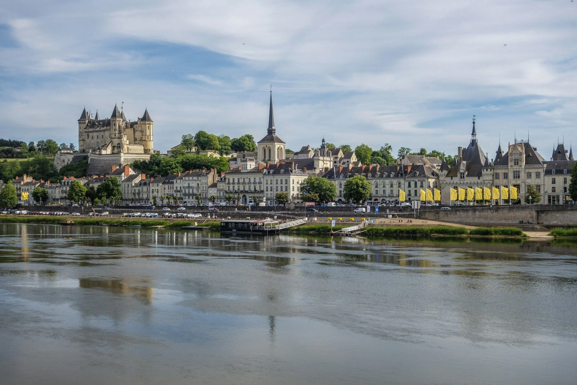
Lots for Sale in Pays de la LoireRegional lots with development potential
Best offers
in Pays de la Loire
Land Plots in Pays de la Loire

Atlantic Growth Belt
Land in Pays de la Loire is most naturally considered for residential building, logistics-linked positioning, and town-edge development because the region combines Atlantic access, strong secondary cities, and broad municipal areas where practical expansion still fits local settlement logic
Coast And Corridor
Few French regions shape land as clearly as Pays de la Loire, where port access, river corridors, productive towns, and suburban belts create plot conditions that depend on connectivity, settlement fit, and realistic year-round regional use
Balanced Momentum
Strategic land value in Pays de la Loire comes from durable regional growth, economic diversity, and a wide network of active municipalities that keep well-positioned plots relevant for residential expansion, mixed-use use, and selective long-horizon development

Useful articles
and recommendations from experts
Land plots in Pays de la Loire and how to compare them by territory
Why land remains highly relevant across Pays de la Loire
Pays de la Loire is not a region with one simple land pattern. It combines Atlantic-oriented zones, strong secondary cities, productive inland towns, agricultural territory, and a broad network of municipalities where land still plays a practical role in real building decisions. Buyers usually consider plots here when they want more flexibility than fixed property formats can provide, especially for residential building, town-edge growth, or land connected to broader regional movement and everyday use.
That makes land relevant in a broad but disciplined way. A parcel in Pays de la Loire is not attractive simply because it is open or relatively accessible. It becomes useful when it fits the territorial logic around it, whether that means a suburban residential belt, a municipal edge with clear local demand, or a corridor-linked site with stronger functional value. Buyers are not only selecting land. They are choosing how that land sits inside one of western France's most balanced regional systems.
How land fits the internal structure of Pays de la Loire
The region should be read through several overlapping geographies. Some areas are shaped by large urban and suburban systems. Others are defined by coastal influence, river corridors, agricultural plains, or productive secondary towns where the rhythm of land use is different. This creates a market where plots behave very differently depending on whether they belong to a suburban edge, a town extension, a logistics corridor, or a lower-density local setting.
River and transport corridors are especially important because they often align settlement continuity, jobs, and accessibility. At the same time, secondary towns and municipal centers create their own land logic, where a site can still perform well without sitting next to the region's largest urban names. In Pays de la Loire, distance from the coast or from a major city explains very little on its own. Connectivity and settlement fit usually matter more than map scale.
Which land-use clusters matter most in Pays de la Loire
The dominant cluster is residential and development-led land use. The region contains many plots suited to detached homes, townhouse rows, compact residential schemes, and structured town-edge building in places where lower-density settlement still feels natural and locally supported. This is one of the clearest regional patterns because there is enough territorial breadth for practical expansion to make sense in many municipalities.
The secondary cluster is logistics-linked and mixed-use positioning. Pays de la Loire carries a strong corridor and port-connected logic, so some plots matter less as purely private residential land and more as practical sites for service activity, storage-linked use, or hybrid formats between municipal and commercial functions. This does not define the whole region, but it is a major secondary layer that shapes how certain locations should be compared.
What kinds of land plots in Pays de la Loire usually make sense
Residential plots in suburban and municipal growth belts are one of the clearest categories. These parcels appeal to buyers who want direct building control while staying tied to jobs, schools, and infrastructure through nearby towns and cities. Their strength usually comes from fitting into established settlement patterns rather than standing outside them.
Town-edge development plots form another important category. In Pays de la Loire, many useful parcels sit where municipalities expand carefully along roads, local service centers, or neighborhood edges. These sites can offer a strong balance between access, scale, and long-term usability, especially for buyers who value practical building conditions over symbolic centrality.
There are also corridor-linked and business-adjacent plots where the logic is more functional than visual. These sites matter because the region's economic diversity and movement structure create real demand for land that supports mixed everyday uses, goods movement, or service-based activity. Their value comes from access and adaptability rather than prestige.
What makes one plot more practical than another in Pays de la Loire
Practicality begins with settlement fit. A parcel that belongs clearly to a town edge, suburban belt, or connected municipal area is usually easier to evaluate than one that looks spacious but sits outside the way the local territory actually functions. In this region, the strongest sites tend to feel like natural parts of an existing settlement structure rather than isolated opportunities.
Connectivity matters just as much. Buyers comparing land for sale in Pays de la Loire should think about roads, rail access, daily movement, and the broader relationship between the parcel and nearby employment or service centers. In such a balanced and distributed region, a plot often performs best when it plugs into everyday circulation clearly rather than relying on one city label or coastal image alone.
Shape, approach, and surrounding use pattern complete the comparison. Two similarly priced plots can lead to very different outcomes if one has a cleaner footprint and stronger local fit while the other is constrained by awkward boundaries, weak access, or a mismatch with the environment around it. Pays de la Loire rewards practical land reading more than simple size or image.
Land in Pays de la Loire versus fixed property formats
Apartments and completed houses offer immediate occupation. Land offers control over format, density, and long-term use. In Pays de la Loire, that difference matters because the region includes many local markets where buyers may want a result more closely matched to their goals than the standard built market can provide.
Land becomes attractive when the final outcome can be aligned more directly with the buyer's needs than a ready property allows. That may mean a private home in a strong municipal belt, a compact residential scheme near a secondary city, or a mixed-use plot in a corridor environment. Land is not automatically stronger, but it becomes compelling when the parcel clearly supports the intended role better than fixed stock does.
How to compare land plots in Pays de la Loire through the VelesClub Int. catalog
When reviewing land plots in Pays de la Loire, buyers should first decide what regional role the parcel is meant to play. Is it a residential plot in a municipal growth area, a town-edge development site, or a corridor-linked mixed-use position? Without that first filter, comparisons quickly become misleading because the region contains several distinct land markets at once.
Once the role is clear, buyers can compare plots by settlement fit, access quality, footprint, surrounding use pattern, and how directly the parcel connects to the wider regional structure. This is where the VelesClub Int. catalog becomes useful. It helps organize land plots in Pays de la Loire by practical territorial logic rather than by isolated descriptions.
VelesClub Int. also helps narrow broad interest into a more disciplined shortlist. Some buyers begin with the idea to buy land in Pays de la Loire for a private project and discover that only certain municipal belts match their daily-use needs. Others start by looking for buildable land in Pays de la Loire and realize that corridor-linked or business-adjacent sites offer stronger long-term flexibility. Structured comparison helps these differences become clear before moving toward a request.
Questions buyers ask about land in Pays de la Loire
Why does land in Pays de la Loire feel varied from one area to another? Because the region combines Atlantic access, productive cities, agricultural territory, river corridors, and many municipalities, so plots belong to several different territorial systems.
What usually makes a plot here more practical? Strong integration into a real settlement pattern, useful transport connection, a clear footprint, and a location that matches the intended residential, mixed-use, or logistics-linked purpose.
Why can a plot outside a major city still perform well in Pays de la Loire? Because connectivity and municipal continuity often matter more than direct proximity to one headline urban center.
Where does land usually make the most sense in Pays de la Loire? Often in suburban municipal belts, town-edge transition areas, connected secondary cities, and corridor-linked zones where the regional network supports practical building decisions.
Is land in Pays de la Loire mainly for private homes? Private residential use is the strongest pattern, but many plots also suit compact development and mixed-use or logistics-linked positioning in the right context.
How should buyers compare actual plot options in Pays de la Loire? By sorting them first by regional role, then checking settlement fit, connection quality, shape, and surrounding use before focusing on city names or coastal image alone.
A strong land decision in Pays de la Loire usually comes from understanding how the regional system actually functions rather than chasing the most obvious available parcel. Reviewing relevant plots in the VelesClub Int. catalog or sending a structured request is the practical next step once the right territorial logic becomes clear.